
View Route Info Route of Month
Featured Routes from previous Months Arundel and Angmering
Hyde Park and Kensington Gardens
Scar House Reservoir Circuit
Hambleton Peninsular
Brunel's Three Bridges
East London Canals
The Long Snake Run
Simonside Summit
|
Featured Route of the Month - October 2012
Simonside Summit (5.00 miles - Trail) |
|
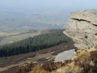
Views from the summit
We have chosen Simonside Summit for the route of the month for October. Despite being quite a high level route the unfoot ocnditions are generally good and the slopes not too steep. To see this route at its best a nice dry autumn day would be ideal. The route reaches a height of 429 metres (1500 feet) at the summit of Simonside. From here you will see some of the great views of Northumberland, with the Cheviots away to the North and Fontburn Reservoir to the South and on a clear day the coast can clearly be followed.
The route itself starts along a lane then, as we said, onto generally good tracks with a only few slightly testing rocky sections. The descent is mostly on a newly laid paved path with again only a few testing sections to take care on.This new flag-stoned path laid in 2010 over the boggy plateau of the Simonside Hills is part of the erosion control measures taken to allow recovery of the original eroded route on the northern edge which is now closed.
Lordenshaw car park is free, but there are no amenities, as is the forest car park at the 1 mile mark (see map). Take care on the quiet lane and on the rocky path especially in the wet. Its not too testing a route but in dodgy weather it would be advisable to take map,compass, food, drink and full body cover.
We have chosen Simonside Summit for the route of the month for October. Despite being quite a high level route the unfoot ocnditions are generally good and the slopes not too steep. To see this route at its best a nice dry autumn day would be ideal. The route reaches a height of 429 metres (1500 feet) at the summit of Simonside. From here you will see some of the great views of Northumberland, with the Cheviots away to the North and Fontburn Reservoir to the South and on a clear day the coast can clearly be followed.
The route itself starts along a lane then, as we said, onto generally good tracks with a only few slightly testing rocky sections. The descent is mostly on a newly laid paved path with again only a few testing sections to take care on. This new flag-stoned path laid in 2010 over the boggy plateau of the Simonside Hills is part of the erosion control measures taken to allow recovery of the original eroded route on the northern edge which is now closed.
Lordenshaw car park is free, but there are no amenities, as is the forest car park at the 1 mile mark (see map). Take care on the quiet lane and on the rocky path especially in the wet. Its not too testing a route but in dodgy weather it would be advisable to take map,compass, food, drink and full body cover.
|

 Good Run Guide - The UK's Leading Independent Running Website