A self-navigation micro event using a GPS tracker.
Runners and walkers can use either the Geo Tracks navigation smart phone app (works in conjunction with the GPS tracker) or upload the course GPX files into their own device.
Participants collect the GPS tracker from the pickup point, follow the course and then return the tracker at the finish drop off point.
Times and GPS traces go up on the leaderboard where you can compare times from previous Hardy Way Marathon’s
Course:
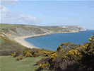
The Hardy Way Trail Marathon is a journey through some of the most unspoiled parts of Dorset. The trail is linked with the works of a great writer, Thomas Hardy (1840-1928). Starting at the Mordon Bog Nature Reserve in Wareham Forest the route passes through Wareham, Corfe Castle, Kimmeridge then on to the coastal footpath all the way to Lulworth. Be warned... the hills get a bit hilly on the coast path…
Navigation:
The course has no specific marking. Participants are to use either the Geo Tracks navigation app or download the GPX file and use their own device. Remember: getting lost is time wasted, check and double-check your navigation. The route is very simple once you reach the coast path! Keeping your head down and simply plowing on without checking your nav won't end well.

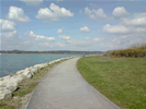
 Holes Bay View - 6.03 miles MODERATE
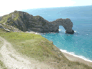

 Good Run Guide - The UK's Leading Independent Running Website