
Quick Links to Other Popular Features
Measure a Route Find a Route Garmin GPS Upload Forum Demo Training Log Become a Member
|
||||||||||||||||||||||||||||||||||||||||||||||||||||||||
Are you the organiser of this race? - Click here to make changes to this race listing |
||||||||||||||||||||||||||||||||||||||||||||||||||||||||
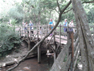
 Pooh''s Forest - 6.87 miles VERY HARD
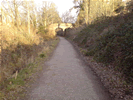 St. Ives - 7.68 miles HARD
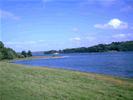 Bewl Water - 12.69 miles HARD
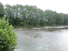 Short Worth Way - 4.60 miles HARD
 Woldingham Trail - 4.77 miles HARD
 Good Run Guide - The UK's Leading Independent Running Website