
Quick Links to Other Popular Features
Measure a Route Find a Route Garmin GPS Upload Forum Demo Training Log Become a Member
|
||||||||||||||||||||||||||||||||||||||||||||||||||||||
Are you the organiser of this race? - Click here to make changes to this race listing |
||||||||||||||||||||||||||||||||||||||||||||||||||||||
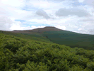
 Sugar Loaf Slog - 5.21 miles VERY HARD
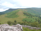 Waun Fach - 6.96 miles
 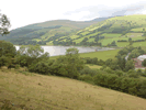 Talybont Tramroad and Canal - 4.85 miles HARD
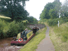 Talybont Reservoir and Canal - 6.11 miles VERY HARD
 Good Run Guide - The UK's Leading Independent Running Website