
Quick Links to Other Popular Features
Measure a Route Find a Route Garmin GPS Upload Forum Demo Training Log Become a Member
|
||||||||||||||||||||||||||||||||||||||||||||||||||||||||||
Are you the organiser of this race? - Click here to make changes to this race listing |
||||||||||||||||||||||||||||||||||||||||||||||||||||||||||
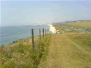
 Brighton Marina Cliff Path - 4.96 miles HARD
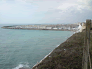 Brighton Views - 6.48 miles HARD
 The Long Snake Run - 9.42 miles VERY HARD
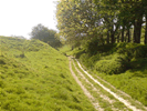 The Short Snake Run - 5.08 miles VERY HARD
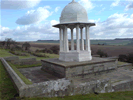 The Chattri on the South Downs - 5.69 miles HARD
 Good Run Guide - The UK's Leading Independent Running Website